


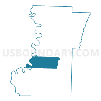
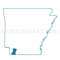
Canfield Voting District, Lafayette County, Arkansas
About
Outline

Summary
| Unique Area Identifier | 527016 |
| Name | Canfield Voting District |
| County | Lafayette County |
| State | Arkansas |
| Area (square miles) | 39.03 |
| Land Area (square miles) | 37.76 |
| Water Area (square miles) | 1.28 |
| % of Land Area | 96.73 |
| % of Water Area | 3.27 |
| Latitude of the Internal Point | 33.17620430 |
| Longtitude of the Internal Point | -93.65606510 |
Maps

Graphs
Select a template below for downloading or customizing gragh for Canfield Voting District, Lafayette County, Arkansas


Neighbors
Neighoring Voting District (by Name) Neighboring Voting District on the Map
- Bradley City Voting District, Lafayette County, AR
- Fort Lynn Precinct, Miller County, AR
- Gin City Voting District, Lafayette County, AR
- Mars Hill Voting District, Lafayette County, AR
- Red River Voting District, Lafayette County, AR
- State Line Voting District, Lafayette County, AR
- Walker Creek Voting District, Lafayette County, AR
Top 10 Neighboring County Subdivision (by Population) Neighboring County Subdivision on the Map
- Roane township, Lafayette County, AR (1,498)
- Steel township, Lafayette County, AR (1,475)
- Walker Creek township, Lafayette County, AR (589)
- Mars Hill township, Lafayette County, AR (157)
- Cut Off township, Miller County, AR (78)
Top 10 Neighboring Unified School District (by Population) Neighboring Unified School District on the Map
- Fouke School District, AR (5,782)
- Lafayette County School District, AR (5,731)
- Bradley School District, AR (2,342)